APPENDIX D – APWA STREET DESIGN CRITERIA
SECTION 5201. GENERAL.
5201.1 Introduction: The purpose of these criteria is to provide uniform procedures for designing and checking the design of streets in Iola, KS. Specific criteria have been developed and are applicable to the types of conditions ordinarily encountered in local urban and suburban areas. Other special situations may be encountered that require added criteria or more complex design than included herein.
In addition to these criteria, street improvements shall be designed to conform to applicable codes, regulations, and ordinances as established by the City. Streets shall be designed in accordance with the classifications determined by the City and shall conform to APWA Standard Drawing Typical Sections, unless otherwise approved. Plans for said improvements shall be submitted to the City for approval and shall include all information as may be required or described hereinafter.
5201.2 Definitions:
City Engineer: The term City Engineer, as used in these criteria, shall represent the state, county, city or other governmental body’s representative responsible for technical decisions concerning the project. Such person may be the Director of Public Works, City or County Engineer, Administrator or any other person empowered by the governing agency to make such decisions.
Engineer: The term Engineer, as used in these criteria, shall represent the Engineer or Designed who performs the actual design work. The design shall be accomplished under the direction of a Registered Professional Engineer. Nothing in these criteria is intended to alter or circumvent local, state or federal laws or regulations regarding liability and/or responsibility for such designs.
5201.3 Abbreviations:
5201.4 Governing Specifications: Design shall be in accordance with the latest edition of the following specifications and the current interim supplements thereto except as modified herein or modified for the specific project:
SECTION 5202. FUNCTIONAL CLASSIFICAITON OF STREETS.
5202.1 Major Arterial Streets (or Primary Arterial, or Urban Principal Arterial): Streets that serve the highest traffic volume corridors and the longest trip. Provides travel between business districts and outlying residential areas, between major inner city communities and between major suburban centers, and connects communities to major state and interstate highways. No or limited access is allowed from residential streets. Access is usually partially controlled. Spacing of major arterial streets is generally from one mile to 5 miles.
5202.2 Minor Arterial Streets (or Secondary Arterial, or Urban Minor Arterial): Streets that interconnect and augment the major arterial streets. No or limited access is allowed from residential lots. Accommodate trips of moderate length at a lower level of travel mobility than major arterial streets. Spacing of minor arterial streets is generally from one-half mile to 3 miles.
5202.3 Industrial/Commercial Collector (or Collector, or Urban Collector): Streets that collect traffic to and from commercial or industrial areas and distribute it to arterial streets.
5202.4 Residential Collector Streets (or Collector, or Urban Collector): Streets that collect traffic to and from residential areas and distribute it to arterial streets. Limited access is allowed from residential lots. Desirable maximum ADT = 3,000 for residential collector streets.
5202.5 Residential Local Streets (or Local, or Urban Local): Streets that only carry traffic having its origin or destination within the immediate neighborhood. Desirable maximum ADT = 1,000 for local streets. (ADT = 10 trips per day per typical single-family residence.)
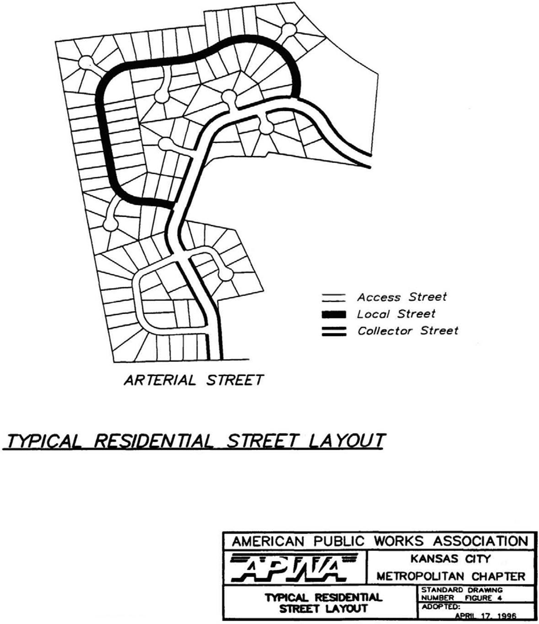
5202.6 Residential Access Streets: Streets that carry traffic between residential lots and residential local streets or residential collector streets. Residential access streets usually carry no through traffic and include short loop streets, culs-de-sac, and courts. Desirable maximum ADT = 200 for culs-de- sac and 400 for loop streets. Maximum length of culs-de-sac = 500 feet and 1,000 feet for loop streets (ADT = ten trips per day per typical single-family residence.)
SECTION 5203. GENERAL STREET DESIGN CRITERIA.
5203.1 Design Criteria: This section governs the general design requirements for the following street classifications (see notes on following page):
| Major Arterial | Minor Arterial | Industrial/ Commercial Collector | Residential(4) Collector | Residential(4) Local | Residential(4) Access | |
|---|---|---|---|---|---|---|
| Number of Through Traffic Lanes(2) | 4—6 | 3—4 | 2—4 | 3 | 2 | 2 |
| Minimum Width of Traffic Lanes (Excluding curb and gutter) | 12 ft. | 12 ft. | 12 ft. | 11 ft. | 12 ft. | 10.5—12 ft. |
| Number of Parking Lanes | 0—2 | 0—2 | 0 | 0—2 | 0—2 | 0—1 |
| Width of Parking Lanes | 8 ft. | 8 ft. | 0 | 8 ft. | 8 ft. | 8 ft. |
| Width of Median | 16 ft. | 0—16 ft. | 0 | 0 | 0 | 0 |
| Minimum R/W Width(5) | 100—150 ft. | 80 ft. | 60—80 ft. | 60 ft. | 50 ft.(2) 45 ft.(1) | 40 ft. |
| Minimum Design Speed mph(8) | 50 | 40 | 35 | 30 | 25 | 20 |
| Minimum Stopping Sight Distance | 400—475 ft. | 275—325 ft. | 225—250 ft. | 200 ft. | 150 ft. | 125 ft. |
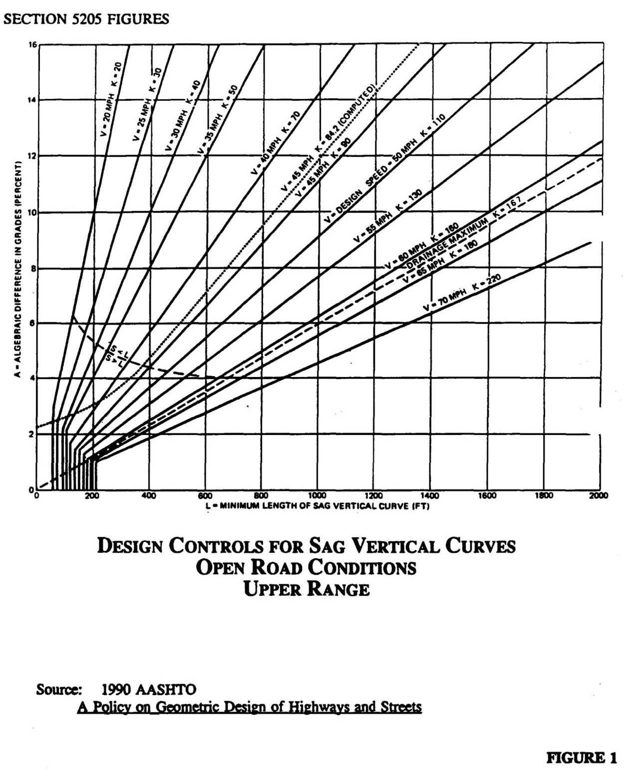
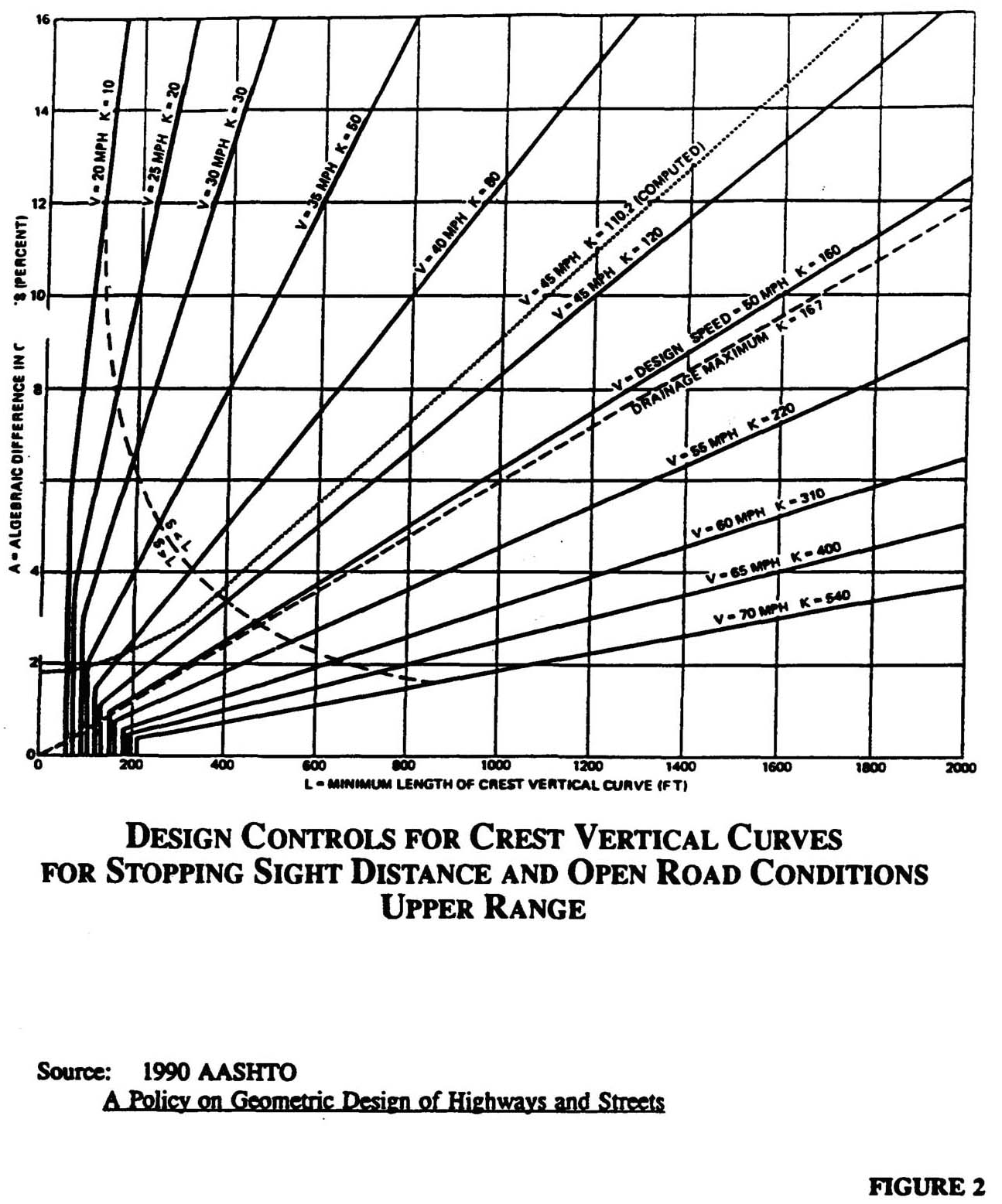
| Minimum K Crest Vertical Curve(3) | 110—160 | 60—80 | 40—50 | 30 | 20 | 10 |
| Minimum K | 90—110 | 60—70 | 50 | 40 | 30 | 20 |
| Sag Vertical Curve(3) | (55 w/lighting) | (35 w/lighting) | (27 w/lighting) | (20 w/lighting) | (14 w/lighting) | (9 w/lighting) |
| Minimum Radii Horizontal Curves(9) | 1,091 ft. (2% Super elevation) | 700 ft. | 500 ft. | 300 ft. | 185 ft. | 100 ft. |
| Minimum Horizontal Sight Distance | (Per AASHTO Requirements) | |||||
| Sidewalks | 2 | 2 | 2 Commercial 1 Industrial | 2 | 1—2 | 0—1 |
| Maximum Grade(6) | 6% | 7% | 6% | 8% | 10% | 12% |
| Minimum Grade(7) | 1.00% | 1.00% | 1.00% | 1.00% | 1.00% | 1.00% |
| Curb Return Radius | 35—50 ft. | 35 ft. | 30 ft. Commercial 50 ft. Industrial | 25 ft. 35 ft. Desirable | 20 ft. 25 ft. Desirable | 20 ft. 25 ft. Desirable |
| Minimum Distance from Intersection of R/W to Driveway Curb-cut | 250 ft. | 200 ft. | 150 ft. | 100 ft. | 25 ft. | 25 ft. |
| Intersection Sight Distance | (See Article 5203.9) | |||||
| Maximum Grade at Intersection with Stop | — | — | — | 3% (within 75 ft.) | 5% (within 50 ft.) | 5% (within 25 ft.) |
| Minimum Spacing of Similar Roadways | (See Section 5202) | 1/4 mile | 200 ft. | 175 ft. | ||
Notes:
5203.2 Maximum and Minimum Gradient: The maximum and minimum gradient for streets as noted in Section 5203.1 may be exceeded only upon written approval of the City.
5203.3 Shoulder Gradients: The finished grade within the limits of the right-of-way shall slope from 2% one-quarter (¼) inch vertical to one foot horizontal minimum, to 4% one-half (½) inch vertical to one foot horizontal maximum measured above the back of the curb. The grading gradients may be varied only upon written approval of the City. Back slopes beyond the R/W line shall be 3:1 maximum, 4:1 desirable.
5203.4 Tangent Length: No tangent length shall be required between reverse curves for residential access and local streets. The minimum tangent length between reverse curves shall be 100 feet for collector/industrial streets. Major and minor arterial streets shall comply with current AASHTO guidelines.
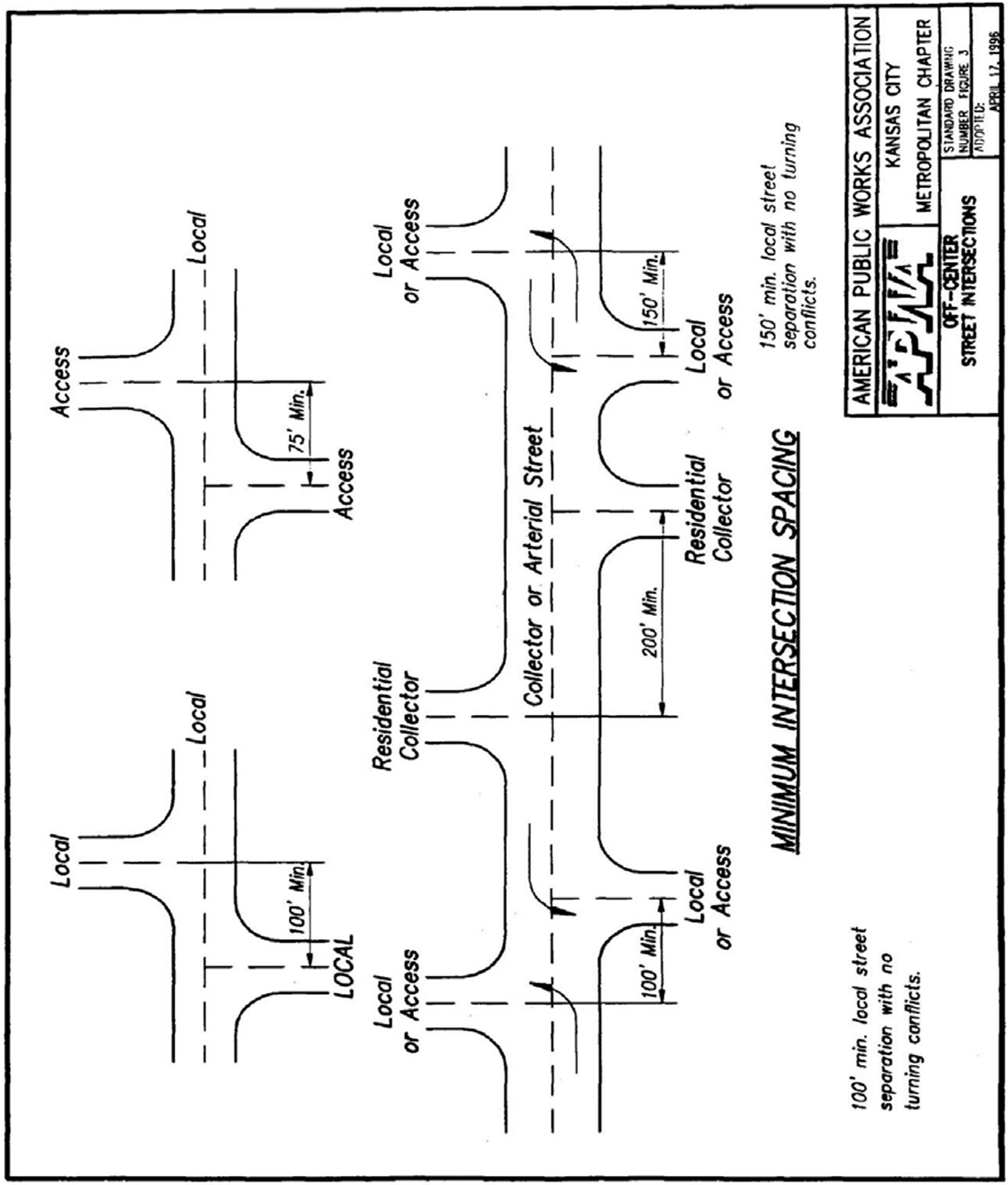
5203.5 Off-Center Street Intersections: Off-center street intersections shall be separated as shown on Figure 3(M).
5203.6 Intersection Angle: It is desirable for all intersections to meet at approximately a 90 degree angle. Skewed intersections should be avoided and in no case should the angle be less than 75 degrees.
5203.7 Intersecting Minor/Major Arterial Streets: Where any minor or major arterial streets intersect each other, the crowns of both streets shall be uniformly transitioned into a plane at the intersection unless otherwise approved. Changes from one cross slope to another should be gradual.
5203.8 Curb Radii: When 2 streets of different classification intersect, the higher classification street shall govern the curb radii dimension listed in 5203.1. Equivalent three-center compound curves may be used in lieu of a single radius curve. Curb ends facing the flow of traffic shall have a 5-foot taper from full height to zero.
5203.9 Sight Distance at Intersecting Streets: Sight distance triangles at intersecting side streets shall be in accordance with the current edition of A Policy on Geometric Design of Highways and Streets, AASHTO. Every effort shall be made to select intersection locations so that the maximum sight distance is possible.
5203.10 Considerations for Connection to Existing and Future Streets: Consideration shall be given to the horizontal and vertical alignment of roadways where they connect to existing streets or where roadways may be extended in the future. Where a new street is to connect to an existing street, all deteriorated or cracked asphalt within 5 feet of the connection point shall be removed to a point where sound material is found. Existing pavement is to be saw cut for the entire width of the street to a minimum depth of 6 inches. If full-depth pavement removal is required, the subgrade shall be re- compacted to 95% of standard density.
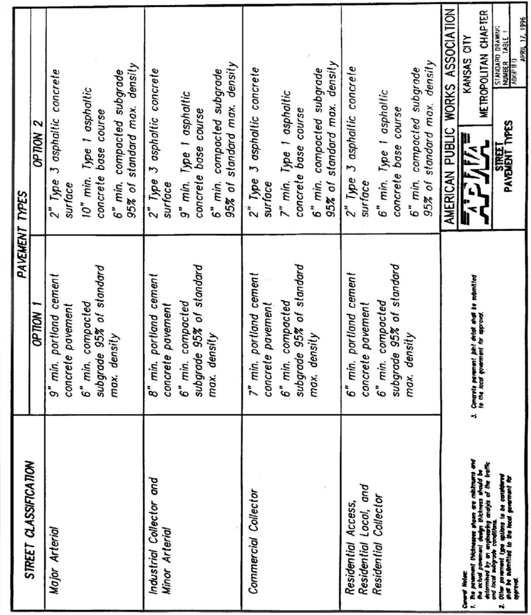
5203.11 Pavement Section: Pavement shall be constructed upon compacted subgrade and of materials and the minimum thickness as shown on the standard drawings for the applicable street classification.
5203.12 Pavement Transition: Reduction in pavement width in the direction of traffic flow shall be accomplished by a taper. The minimum desirable length for merging taper shall be determined by the formula L = WS2/60 where posted speeds are 45 mph or less. The formula L = W x S should be used for roadways having a posted speed limit greater than 45 mph. Under either formula, L = taper length in feet, W = width of the closed lane in feet, and S = design speed in mph.
5203.13 Culs-de-Sac: At locations where streets are to be terminated and a vehicular connection between adjacent streets is not required, the termination shall be a cul-de-sac. Such cul-de-sac shall be constructed with a minimum radius of 39 feet to the back of the curb if there are no islands located in the cul-de-sac.
5203.14 Temporary Turn-Arounds: At locations where streets will be temporarily terminated and which will be extended at a later date, and said street extends beyond the intersection of an adjacent street more than 150 feet, a temporary cul-de-sac shall be constructed with a minimum radius of 35 feet. The temporary cul-de-sac shall be constructed of asphaltic concrete with a minimum depth of 8 inches. Curb and gutter will not be required. The cul-de-sac shall be constructed within the limits of temporary easement.
Temporary turn-arounds shall be located so that they do not interfere with permanent development. They should normally be located on property adjacent to the property to be served. For new subdivision plats, they should be located on property beyond the limits of the plat.
5203.15 Driveway Grades: Driveway grades shall conform to the typical section of the street within the right-of-way. Any deviations shall be approved by the local government official with the following limitations: Driveways shall attain a minimum elevation of 6 inches above the gutter elevation within the right-of-way with a maximum grade of 8%. The algebraic difference in grades at the right-of-way on crest drives shall be 8% maximum and on sag drives shall be 12% maximum. The maximum driveway grade outside the right-of-way shall be 15%.
5203.16 Access for the Disabled: Ramps shall be required at all planned sidewalk-curb intersections in accordance with standard practice and approved by the City. Non-standard driveways and alleys will also be designed to accommodate the handicapped.
5203.17 Street Lighting: All street lighting shall be designed in accordance with Section 5800 of the APWA design criteria unless otherwise directed or approved by the City.
5203.18 Storm Drainage: All storm drainage shall be designed in accordance with Section 5600 of the APWA design criteria unless otherwise directed or approved by the City.
5203.19 Underdrains: In areas that have known subsurface moisture problems, underdrains or drainage blankets shall be designed.
5203.20 Erosion Control within R/W Limits: As a minimum, all grass areas in the R/W shall be seeded and mulched to control erosion on to the roadway. All construction projects that have exposed grading require temporary erosion control measures. Temporary erosion control must be approved by the City Engineer.
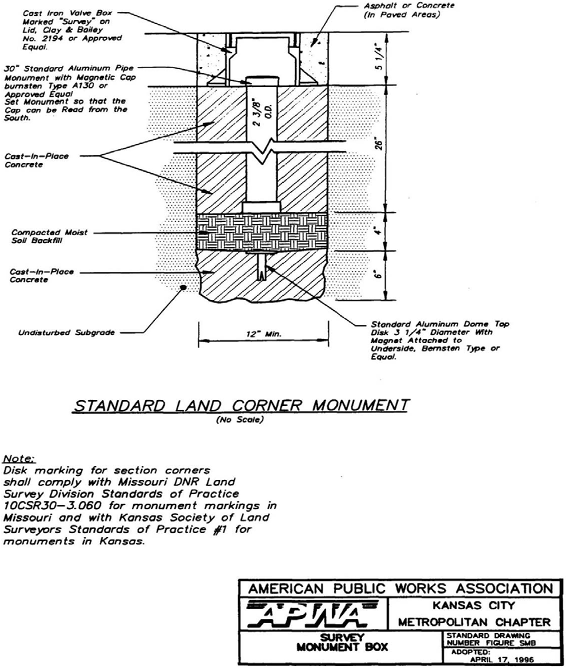
5203.21 Survey Monument Boxes: Monument boxes conforming to Figure 5 shall be installed at all quarter section corners involved in the street construction. The monument boxes shall be set by a Registered Land Surveyor licensed in the state the monumentation work is performed.
5203.22 Traffic Impact Studies: Required where developments have adverse impact on existing traffic conditions.
5203.23 Obstructions: Rigid structures such as poles and hydrants shall be placed a minimum horizontal distance of 1.5 feet from the face of curb to edge of obstruction. When required, guardrail and barricades shall be installed in accordance with the AASHTO Roadside Design Guide or local policies. Vertical clearance of a minimum 14.5 feet shall be provided. Along sidewalks, a minimum vertical clearance of 7 feet shall be provided.
5203.24 Other Design Criteria: Design criteria not covered by this document shall be in accordance with the most current edition of A Policy on Geometric Design of Highways and Streets by the American Association of State Highway and Transportation Officials (AASHTO) or other applicable AASHTO design guides.
SECTION 5204. GENERAL PLAN REQUIREMENTS.
5204.1 Scope: This section governs the preparation of plans for street projects.
5204.2 General: The plans shall include all information necessary to build and check the design of streets and related appurtenances. The plans shall be arranged as required by the City Engineer of Iola. Applicable standard plans of the City may be included by reference to standard plan number and title. Plans shall be sealed by a Registered Professional Engineer in the state of Kansas and shall be submitted to the City for review and approval.
5204.3 Scales: Plans shall be drawn at the following minimum scales. Larger scales may be needed to clearly present the design. Bar scales shall be shown on each sheet for each scale.
| Plan: | 1 inch = 50 feet | Suburban |
|---|---|---|
| 1 inch = 20 feet | Urban | |
| Profile: | ||
| Vertical: | 1 inch = 10 feet | Suburban |
| 1 inch = 5 feet | Urban | |
| Horizontal: | 1 inch = 50 feet | Suburban |
| 1 inch = 20 feet | Urban | |
| Drainage Area Map: | ||
| On site: | 1 inch = 200 feet | |
| Off site: | 1 inch = 1,000 feet | |
| Structural Plans: | 1 inch = 1 foot | |
| Graphic Drawings: | Varies |
5204.4 Sheet Sizes: The suggested plan sheet size is 22 inches × 36 inches, 22 inches × 34 inches, or 24 inches × 36 inches with all sheets in a given set of plans being of the same size. Plan and profile shall be drawn on combined or separate plan and profile sheets to minimum scales shown above.
5204.5 Types of Sheets in Plans: The plans shall consist of:
Each sheet should contain a sheet number, including the individual sheet number and the total number of sheets, proper project identification and date. Where feasible, storm sewer construction details should be incorporated into the street plans. The engineer’s seal shall appear on the title sheet.
5204.6 Required Information for Title Sheet:
5204.7 Required Information for General Layout Sheet:
5204.8 Required Information for Plan and Profile Sheets:
5204.9 Required Information for Cross-Section Sheets:
5204.10 Required Information for Standard and Special Detail Sheets: Detail sheets shall be included to show all details of appurtenances, materials, and construction. Details shall conform to the requirements of the City and are to be drawn clearly and neatly with proper identifications, dimensions, materials and other information necessary to insure the desired construction.
5204.11 Required Information for Lighting Plans: Street lighting plans shall be prepared in accordance with Section 5800 of the APWA design criteria and included in addition to the street improvement plans for approval. The plan shall be at 1 inch = 50 feet (minimum) scale with the streets and adjacent plats labeled.
5204.12 Required Information for Traffic Control Plan Sheets:
5204.13 Required Information for Temporary Erosion Control Plan Sheets: